Skip to content

Upcoming Live Webinars

Contrail software for environmental monitoring

Training for Contrail® Users and Administrators

OneRain is pleased to offer FREE monthly web-based training sessions to our valued customers! Each live session is aimed at new or experienced Contrail Users or Administrators who want to refresh or expand their knowledge of the software and how to manage and understand their environmental, hydrological, and meteorological data from an operational perspective.

Our live webinars cover topics about flood prediction, data analysis, decision support, and the management, dissemination, and communication of alerts, as well as precipitation processes.

Monthly Live Webinars

Check back often!  In addition to our monthly Contrail Training Series webinars, we also conduct some special webinar training workshops. Our training schedule and topics below may change from time to time due to the introduction of new features, holidays, or other conflicts. Estimated duration is 45 minutes to 1 hour. Select topic to view more information.

Don’t forget—all of our live training webinars provide a great chance to ask any questions you might have. These sessions also provide the opportunity to learn about any recent updates and enhancements to the software and technologies.

Registration is required for each live webinar. To attend, complete the Webinar Registration form.

Schedule and Topics

Thursday, September 14, 2023
at 10 AM Pacific / 1 PM Eastern

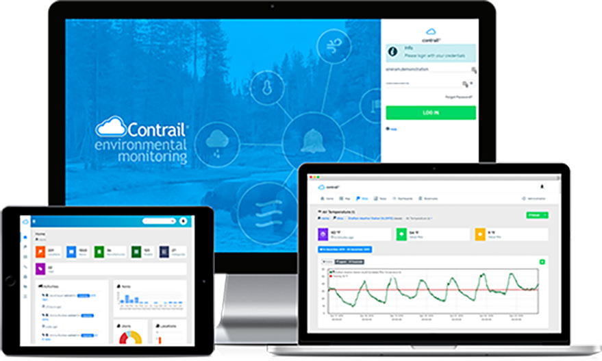
Contrail®: Creating Synthetic Sensors through Equations and Rating Tables

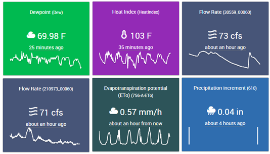
Learn the ins-and-outs of setting up hydrometeorological equations in Contrail during this live training session! We'll walk you through how to create Synthetic Sensors using equations and rating tables, and we'll explain the main differences between these 3 types of derived sensors: •­ Synthetic Sensors (e.g., Rain Increment, Flow Rate using a Rating Table) •­ Equation Sensors (e.g., Dew Point, 24-Hour Average, 1-Hour Accumulation) •­ Time Series Sensors (e.g., Time Series 24-Hour Rain Accumulation, ETo)

Thursday, October 12, 2023
at 10 AM Pacific / 1 PM Eastern

Contrail Analytics

Contrail® Analytics: Exploring Data Analysis and Reporting

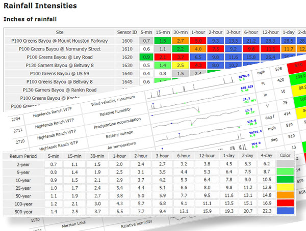
Extreme rainfall and flooding events put our real-time monitoring systems to the test and help us all learn what works well during an event (and what doesn't). Our assessments in the aftermath of such storms are what drive us to make our systems stronger and smarter. Contrail Analytics is just one of the resources we use to perform the data analyses that helps us understand what occurred during a storm event, how well gauges worked, and how well our hydro-meteorological data reporting systems performed.

View Previous Webinars

Assessing Flood Risk: The First Principle of Flood Early Warning Systems

Know your flood risk. It’s internationally accepted as the very first pillar on which every flood early warning system around the globe should be built. If you don’t get it right, the effectiveness of the entire system can be compromised. Yet, assessing flood risk can be highly complex. In this second installment of our webinar series, we break risk assessment into more manageable steps. We explain each of the variables you need to consider and how they can be systemically combined into an overall evaluation of flood risk.

Four principles to guide you when developing a flood warning system. Image of flooded roadway.

Four Principles To Guide You When Developing A Flood Warning System

If the prospect of developing a new or expanded flood warning system feels overwhelming, don’t worry. You’re not alone. In this webinar, we lay out a basic framework for approaching these decisions and break it down into four main principles you can follow. Watch the on-demand webinar now. We discuss how to:

  1. Understand your vulnerabilities. (Who, what, when, and where is at risk for flooding).
  2. Determine the optimal system design (sensors, telemetry, and software to effectively reduce and mitigate risks).
  3. Identify communication pathways (for disseminating critical information about threats).
  4. Ensure long-term system resilience (so you can always be prepared).

Are you Prepared? Predictive tools to mitigate flood risk.

The growing frequency and intensity of flood events around the world have driven the need for more accurate forecasting and real-time hydrologic simulation. A predictive flood modeling system can provide information necessary about flood timing and intensity for critical decision-making during an event, both forecast and in real time. This webinar, presented by Dr. Kelsey McDonough, Professional Services Manager and Hydrologic Engineer with AEM, discusses and shows real-world examples of how a predictive flood modeling system can provide information necessary about flood timing and intensity for critical decision-making during a storm event.

Flood Warning System Telemetry

In this webinar we discuss different telemetry options for environmental monitoring and flood warning sites and systems. We cover the “pros and cons” of a variety of commonly used telemetry available for these types of gauges/sites, such as: GOES, ALERT/ALERT2, IoT technologies like cellular, LoRoWan and others, Inmarsat, Iridium, Narrow-band UHF/VHF Radios, and more. We also take a look at “best practices” for installations and what type of telemetry to consider based upon site, cost and needs.

Utilizing Lightning and Radar Services in Contrail® for a Complete Hazard View

Convective thunderstorms and in-cloud lightning usually serve as an early indicator of extreme weather — from intense heavy rainfall, hail, and flash flooding, to dangerous cloud-to-ground lightning strikes, straight-line winds, and tornados. The Lightning Data Services add-on to Contrail® enables you to track, report, visualize and alert on these very types of events.

This educational webinar workshop explores how you can leverage lightning data in Contrail for complete situational awareness and multi-hazard early warning. Learn about the early indicators of extreme weather — from intense heavy rainfall, hail, and flash flooding, to dangerous cloud-to-ground lightning.

Dam Safety: Disaster Risk Reduction With Real-Time Monitoring

Dams create risk. Dams rated as high- and significant-hazard pose varying degrees of risk for human life and property, both upstream and downstream. The best way to understand and to help mitigate that risk is to know the current conditions at, below, and upstream of the dam. Automated real-time monitoring offers the most cost effective way to reduce risk at dams, especially remote, unmanned dams.

This webinar discusses best practices for remote monitoring at varying types of dams with practical takeaways and things you can do right away to reduce your risk.

Flooded Roadway Warning Systems – A Webinar Workshop

This was a joint webinar workshop presentation by our HydroMet team with experts from High Sierra Electronics, OneRain Incorporated and FTS Inc. This webinar explores the use of High Water Detection Systems (HWDS) where sensors at the low flood-prone point in the road can automatically activate flashing beacons up ahead in the road in each direction to warn motorists of the danger ahead. The discussion includes site selection and deployment options, 2-way controls, and provides real-world examples and best practices.

Water Level Sensor Technologies And Best Practices

In this webinar we provide an overview of water level sensor technologies for hydrological monitoring. Discussed are the types of instrumentation and measurement methods used for different applications and operational requirements. We look at the challenges of measuring water levels in a wide range of conditions, and offer best practices and recommendations in determining which solution to utilize.

Acquiring A Complete View Of Road Weather Hazards To Operate Effectively

Weather can impact roads at any time of the year and at a moment’s notice. From large winter storms to quick flash flooding, weather events present unique challenges for anyone responsible for maintaining roads and safe driving conditions. Impacts can range from minor traffic delays to life-threatening situations for motorists and workers alike. Many weather conditions, including heavy precipitation, fog, snow, freezing temperatures, and high winds, can lead to dangerous hazards for motorists and cause costly weather-related traffic delays. This webinar presents a complete road hazard approach that gives transportation managers and decisions makers all the information they need for any weather-related impact on their roads, as well as automatically alerting motorists of hazardous situations.

Prefer one-on-one training?

OneRain can provide customized training tailored to your needs. For more in-depth training with your own system, equipment and data, we can provide custom virtual training classes, or come to you! Contact us to arrange customized training for groups of 4 or more.

Not on our mailing list?

Don’t miss out! Join our mailing list to receive e-mail alerts about our upcoming webinars, technical updates and other important product announcements.

We respect your privacy and take protecting it seriously. Learn more about OneRain’s Privacy Policy to learn how we use your contact information.