Some of our Customers
Focus on Quality and Completeness - End-to-End
OneRain’s customers understand their mission and know the importance of timely, accurate, complete data. Their networks are maintained, sensors are calibrated, and their telemetry is designed to get all of the data there in real-time. They use Contrail® (now part of AEM Elements® 360) to collect and manage their environmental and water and weather-related data.
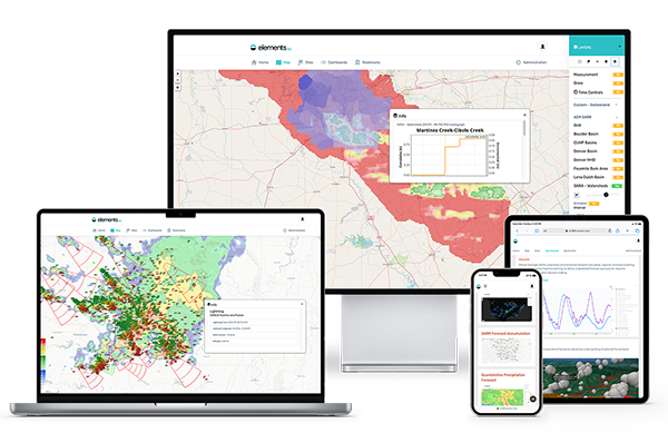
The examples below show public-facing views of the software. Front-end views are entirely flexible—you decide what you’d like your users to see—even create different views of your data for different end-users. What you won’t see here are all the powerful behind-the-scenes processing, analytics, and data management tools that transform the way you see and understand your data.
We’d love to show you around and discover how AEM Elements® 360 can meet your needs. Contact us today for a personalized one-on-one full demonstration.
Public-Facing Website Views – Real Life Examples
Below is a selection of just some of our valued clients. Follow the links below to visit their live public-facing websites powered by AEM Elements® 360 that showcase just some front-end features, functionalities and flexible reporting options.

Sonoma County Water Agency, California
In October 2017, the Sonoma County region experienced damaging firestorms. The resulting fire burn scars and ground conditions throughout the Tubbs and Nuns area left the region highly vulnerable to life-threatening flash flooding and debris flows during heavy rainstorms. Heading into the rainy season, a flood warning network was needed as quickly as possible. Led by Sonoma County Water Agency with assistance from OneRain, a complete ALERT2™ flood warning network was designed and installed from the ground-up to assist the County and National Weather Service in detecting flooding conditions. A new fully functional ALERT2 flood warning network was operational by the end of February 2018.
Public Website Home Page: https://sonoma.onerain.com/
Regional Map: https://sonoma.onerain.com/map/
Explore Dashboards: https://sonoma.onerain.com/dashboard/
County of Sacramento, California
Sacramento County Rainfall and Stream Level Information System comprises two self-hosted Contrail instances and approximately 50 gauging sites.
Public Website Home Page: https://www.sacflood.org/
Explore Dashboards: https://www.sacflood.org/dashboard/list/
Trinity River Authority - Lake Livingston, Texas
The Trinity River Authority of Texas is a conservation and reclamation district that provides water from reservoir facilities, water and wastewater treatment, along with recreation and reservoir facilities, within the nearly 18,000-square-mile Trinity River basin. TRA employs a suite of tools to manage their operations: Contrail, GateOps and real-time StormData GARR services track inflow, reservoir storage, water levels and gate positions for Reservoir Operations Management.
Public Website Home Page: https://lakedata.traweb.net/
Explore Dashboards:
Stage Levels
Current Reservoir Conditions
City of Overland Park/Johnson County, Kansas
Overland Park/Johnson County StormWatch system public website provides real-time data from over 170 remote weather stations located throughout the Kansas City Metropolitan area. The majority of the stations report real-time rainfall, and many also report stream levels, air temperature, humidity, wind speed/direction, and other weather data. The system also brings in Road Weather Information from a series of road weather sensors that measure air temperature, road surface temperature, and the conductivity of moisture on the road surface. Overland Park’s system integrates ALERT/ALERT2, RWIS (Road Weather Information System) data, as well as other available regional data (METAR airport weather), and USGS).
Public Website Home Page: https://www.stormwatch.com
View of sites and sensors: https://www.stormwatch.com/map/
Example of Road Weather: Road Weather Information System (RWIS) Dashboard
Additional Dashboards: https://www.stormwatch.com/dashboard/list/
Elephant Butte Irrigation District, New Mexico
Contrail tracks storm activity for potential flood warning alerts, flood control dam safety, and to capture and divert storm water run-off for the purpose of aquifer replenishment and field irrigation. The system features data collected via Remote Telemetry Units (RTU) installed on watershed weather stations, rain gauges, flood control dams, arroyo channels, river stations, and diversion locations. EBID implemented Contrail software to manage all the data and to assist and alert field personnel of accumulated rainfall and potential storm water run-off. Contrail, in combination with the field monitoring equipment, enables EBID management to track storm movement and accumulated rainfall totals.
Public Website: https://onerain.ebid-nm.org/
Regional View: Pan and Zoom Map
Dashboards: https://onerain.ebid-nm.org/dashboard/list/
EBID Portal: https://www.ebid-scada.org/
Mile High Flood District, Denver, Colorado
Review real-time rainfall-related and weather activity throughout the region. The District covers Denver and parts of the six surrounding counties: Adams, Arapahoe, Boulder, Broomfield, Douglas and Jefferson. The area includes 32 incorporated cities and towns.
Public Website: https://mhfd.onerain.com/
Regional view: pan and zoom map
Dashboard Example: Maple Grove Reservoir Gates
Additional Dashboards: List
San Jacinto River Authority, Texas
This site provides rainfall totals, flow rates, stage information, weather activity, and historical data throughout the area. Rainfall Visualization & Decision Support. Integration of ALERT via direct and via OneRain’s StormLink satellite concentration.
Public Website Home Page: https://sanjacinto.onerain.com/
Regional view: pan and zoom map
Dashboard example: Lake Conroe
Santa Cruz County, California
Flood Control District, Flood Control and Water Conservation, Water. Integration of ALERT and USGS, RAWS and third party data.
Public Website Home Page: https://santacruz.onerain.com/
Regional view: pan and zoom map
Dashboard example: Pajaro Summary

Doña Ana County Flood Commission, New Mexico
This Regional Real-time Hydrologic Monitoring Network, managed by the Doña County Flood Commision, is a collaborative project of the Doña Ana County Flood Commission, the Elephant Butte Irrigation District, the City of Las Cruces, the National Weather Service, and New Mexico State University. A dual server Contrail architecture enables Dona Ana County Flood Commission to operate in mission critical mode in addition to providing a public URL website that presents data from their network of gauges. The system aggregates a number of additional gauging sources from other agencies, including USGS and local irrigation districts, into their Contrail data collection software platform.
Public Website Home Page: https://weather.donaanacounty.org
Regional view: pan and zoom map
Rainfall accumulation: Weekly, Monthly and Annual Precipitation

County of Marin, Flood Control and Water Conservation District, California
Real-time Rainfall, Creek Stage, and Weather Data. Integration of ALERT, USGS and TIDES data sources.
Public Website Home Page: https://marin.onerain.com/
Regional view: pan and zoom map
Explore Dashboards: https://marin.onerain.com/dashboard/

County of Santa Barbara, California
Real-time Rainfall, River-Stream, and Reservoir Data. Integration of ALERT and USGS data sources.
Public Website Home Page: https://rain.cosbpw.net/
Regional view: pan and zoom map
Harris County Flood Control District, Texas
HCFCD operates a three-server Contrail Base Station implementation, and full support for nine (9) partner agencies. Integration of ALERT/ALERT2 and multiple agency data sets, with distance weighted rainfall overlay. Customer-created maps, specialized Sensor notes with tabs, Flood Frequency/ Historical Floods, Site Images, Rain Summary, Water Level Summary, …
Public Website Home Page: https://alert.hcfcdcontrail.org/
Water Levels: Current Levels
Weather Sites: Dashboard Display
Example Sensors: Graph

Napa County, Napa Valley Regional Rainfall and Stream Monitoring System, California
Rainfall and Stream Level Data for the Napa Valley Area. Integration of ALERT, METAR, USGS and HADS data sources. The network of rainfall and stream level gauge sites is a collaborative project of local Napa County cities, the County of Napa, and the Napa County Flood Control and Water Conservation District. The site provides public access to a network of approximately 50 site locations in the Napa Valley region where weather or stream data collection equipment are located.
Public Website Home Page: https://napa.onerain.com/
Regional view: pan and zoom map

San Joaquin County, California
Rainfall and hydrometeorological data for San Joaquin County.
Public Website Home Page: https://sanjoaquin.onerain.com/
Regional view: pan and zoom map
Example Dashboards: Gauges at a Glance

Ohio Emergency Management Agency – Statewide System
Statewide real-time stream and rainfall network. Ohio EMA’s STORMS system has 416 precipitation and 75 river stage gauges reporting into the system. These gauges are located in 65 Ohio counties and provide real time precipitation data to the National Weather Service and to local governments for flood forecasting.
Public Website Home Page: https://storms.storms.ohio.gov/
Statewide view: https://storms.storms.ohio.gov/map/