Built for scalability and reliability, AEM Elements 360 integrates seamlessly with a wide range of environmental sensors and data sources. Whether you’re managing a single site or a complex network of monitoring locations, the software enables you to track dynamic conditions as they unfold—helping you respond quickly to changing weather, flooding threats, or infrastructure stress.
With real-time visualization tools, automated alerts, and advanced reporting features, AEM Elements 360 empowers flood and water resource managers, dam operators, and emergency responders with the situational awareness needed to safeguard communities, infrastructure, and the environment.
FEATURES
- 24×7 Web-Based Desktop and Mobile Access—Secure, managed access for unlimited users via desktop or mobile—no special apps required. Users can visualize, analyze, and manage data using a standard web browser, whether on an internet or intranet connection.
- Seamless Integration of Data from Many Sensor Types. Collect and consolidate data from a wide range of sensors and platforms, including StormLink®, ALERT/ALERT2, Davis Instruments, Lambrecht meteo, FTS, USGS, METAR, RAWS, HADS, CDEC, Tides, GoData, RWIS, SCADA, Modbus, IoT sources, and more.
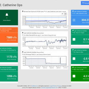
- Real-Time & Historical Data Viewing. Access and review both real-time and archived data from various sensor types, such as rainfall, streamflow, water level, stage, wind speed/direction, and temperature. Easily share selected data with the public or stakeholders.
- Dynamic Visualizations of Current Conditions. Understand system status at a glance with intuitive, up-to-the-minute maps, real-time dashboards, widgets, graphs, charts, and data tables—customizable for different user needs.
- Automated Emergency Alerts & Notifications. Trigger early warning alerts and messaging automatically based on user-defined thresholds and evolving conditions. Supports rapid response to potential flood threats and hazardous events.
- Advanced Alert Management & Decision Support. Create complex alarm logic using Boolean/expert equation tools. Tailor alarm conditions and automated messaging to align with Emergency Action Plans (EAPs), decision criteria, and escalation workflows.
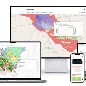
- High-Resolution Mapping with GIS Overlays. Visualize sensor locations, status, and conditions with interactive pan-and-zoom maps. Integrate radar imagery, spatial rainfall, flood inundation layers, and GIS data for richer situational context.
- Integrated Reporting & Analysis Tools. Generate detailed reports, perform historical analyses, and gain insights through built-in tools designed to support planning, compliance, and operational optimization.