Predicting El Niño’s flood risk: How new warning systems save lives, property

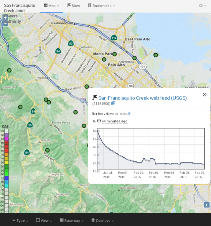
In the news February 2016: “Predicting El Niño’s flood risk: How new warning systems save lives, property”. OneRain’s Contrail® software provides the real-time monitoring and alerting for San Francisquito Creek Joint Powers Authority’s newly launched Flood Early Warning System. Check out this great article by journalist, Lisa Krieger with the Mercury News, focused on how automated remote data systems are helping protect communities in the San Francisco Bay area.

News Source: Lisa Krieger, San Jose Mercury News

Four winters ago, as worried rescuers watched the quickly rising waters of a Peninsula creek and tried to decide whether to alert local residents, they turned to a small green plant for guidance.

“You see that shrub?” one public safety official said. “When it’s under water, we’re going to start evacuating.”

Today, that sentinel shrub has been replaced by a sophisticated network of gauges, sensors and computers that can save lives and property — not only in flood-prone Menlo Park, Palo Alto and East Palo Alto, but also in vulnerable South Bay and East Bay communities.

OneRain’s Contrail® software provides the real-time monitoring and alerting for San Francisquito Creek Joint Powers Authority

Counting El Niño’s raindrops in distant mountains, the new flood-prediction systems are for the first time allowing the Bay Area to anticipate disasters, not merely respond to them.

“We can ramp up, adding resources and personnel,” said Menlo Park Fire Chief Harold Schapelhouman. “It becomes part of normal planning.”

A revolution in technology allows for the highly automated and near-instantaneous analysis of enormous volumes of digital information about water flow.

It works like this: Separate streams of data — collected from mountain peaks and rushing creeks — are integrated into huge databases. Computers then track rising waters and predict flood risk, based on creekbed capacity and the surrounding landscape.

As waters run high, the computers can issue an electronic flood alert to local residents downstream. For instance, mid-Peninsula residents who are registered to get an alert — by text or email — are kept informed about four different flood-prone locations along San Francisquito Creek. They will be notified nearly two hours in advance of the water overflowing its banks.

“We know what is coming down the system,” said Len Materman of San Francisquito Creek’s Joint Powers Authority, which has a newly expanded system of automated rain and creek gauges perched 2,000 feet above the vulnerable mid-Peninsula cities. “We can give people solid information for decision-making” about such things as when to sandbag, get electronics and antiques off the floor or seek higher ground.

To be sure, even the most high-tech upstream tools can’t predict flooding from surprise local sources, such as a suddenly downed tree or a blocked storm drain.

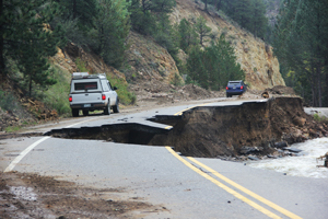
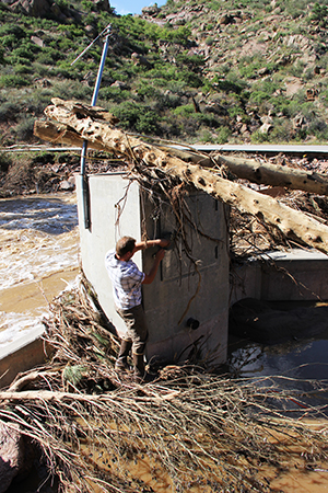
While we’ve long been able to accurately forecast flooding on major water routes like the Sacramento River, the risk along smaller urban tributaries — prone to flash floods, especially if lined with concrete — has been far tougher to predict.

Flooding is the leading cause of severe weather-related deaths in the U.S., causing 75 to 200 drownings per year. Because cars can be swept away in only 1 to 2 feet of water, about half of the drownings are vehicle-related.

In the last strong El Niño in the winter of 1997-1998, 1,700 homes were flooded on the Peninsula, and some residents had to be evacuated by boat. There also was damage in other Bay Area communities.

But history isn’t much help in predicting future risk because every storm is unique, with different rainfall patterns, experts say.

Steve Fitzgerald, president of the National Hydrologic Warning Council, has witnessed the recent and dramatic expansion of real-time, high-quality hydrologic information.

In 1983, as Hurricane Alicia bore down on his city of Houston, he was frustrated and fatigued by attempts to identify danger. Working 24 hours straight, he used a Wang computer to plot the data delivered by the county’s 12 rain gauges, imperfect devices rigged with weights and cables. Each graph took him 45 minutes to complete. Then, as rains pounded the city, the information quickly became obsolete and needed to be updated.

Now computer analyses of his county’s 150 electronic gauges and sensors take only seconds. “There has been quite a transformation,” said Fitzgerald, chief engineer of the Harris County Flood Control District.

Other cities with state-of-the-art flood prediction capabilities include Denver, Las Vegas, Los Angeles and Charlotte, North Carolina.

In the Bay Area, the newly expanded mid-Peninsula network was designed by hydrologists and data-crunchers at Berkeley-based Balance Hydrologics, using property volunteered by Stanford University, the Midpeninsula Regional Open Space District and San Mateo County Parks.

The Santa Clara Valley Water District has a network of 70 stream and rain gauges throughout the county, located along Los Gatos Creek, Stevens Creek, Alamitos Creek, Uvas Creek, the Guadalupe River and other sites.

Contra Costa County has three stream gauges, 29 rain gauges and one reservoir gauge, and it just received a grant to add 10 more stream gauges. It monitors Marsh Creek in the eastern part of the county and Walnut Creek in the central part of the county.

In Alameda County, a network of about 90 rain and stream gauges collects data used to estimate potential flood conditions. In the future, the county plans to expand its network to develop a database and Web tool that can be downloaded by residents.

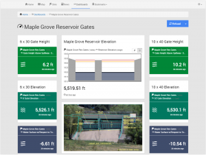
The magic of the new technologies is that they can identify an emerging risk miles — and hours — away. Gauges, powered by solar panels, can accurately send electronic signals to data loggers via radio, landlines, cellphones or satellites. This data is more quickly analyzed due to increased computer power. And the flood risk is instantly communicated to nearby residents.

But, Materman said, it’s not enough to just gather information: “The first half of the problem is better data. The second half is: How do the public and emergency responders use that data?”

Increasingly, residents can go online to track water levels and changes in flow rates, said Gary Kremen, a board member of the Santa Clara Valley Water District. “There is greater transparency. It is empowering.”

But how well will this all work?

This winter’s El Niño could put it to the test.

“It is a work in progress,” Materman said. “Our work is based on models. We’ll need to ‘ground truth’ it.”

It’s far better, though, than keeping a watchful eye on a shrub, he said. “But it will take a real storm to see whether it behaves like we predict it should.”

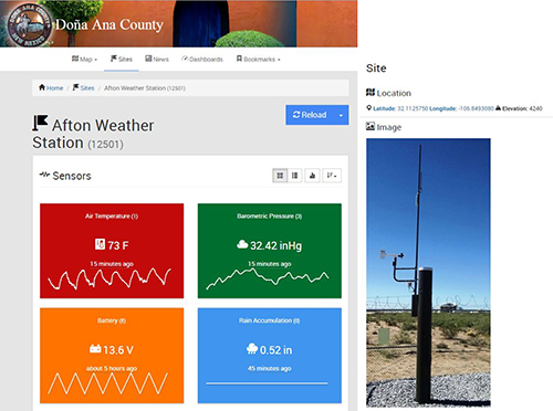
  • BETTER GAUGING STATIONS: Rain gauges are 10-foot-tall pipes with a funnel, bucket and tipping mechanism at the top; each tip measures 0.04 inches of rainfall. Creek gauges have a membrane that precisely measures the depth of water and converts it into a flow rate, expressed in cubic feet per second.
  • IMPROVED DATA TRANSMISSION: Each time the rain gauge’s lever tips, its tiny internal computer sends a high-frequency radio transmission with the tip counter numbers to a receiver or repeater, then to a computer system. In creeks, the gauges convert the water’s depth to a flow rate, then transmit signals via phone lines.
  • FASTER ANALYSIS: With ever-increasing computer power, software processes the many signals into a computer database, which monitors the information as it is received. It triggers a warning when certain thresholds — say, water filling 80 percent of a creek’s capacity — are reached. Because different locations have different flood risks, the warnings can be localized.
  • ADVANCED COMPUTER MODELING: Instant access to project data is available through a cloud-based data center and can be viewed in real time or as a graph to identify trends. Using advanced math, topographic models can predict where and when water will likely go, if flooding occurs.
  • CELLPHONE ALERT SYSTEMS. In 2012, a California law went into effect that allows emergency alerts to be sent to cellphones, allowing flood control agencies to send automated warnings directly to the cell towers of major U.S. carriers, which then transmit those messages by text or email to phones. Residents of some communities can also track flood risk on websites.

###

Full Article Source: http://www.mercurynews.com/drought/ci_29453899/predicting-el-ninos-flood-risk-how-new-warning
Contact Journalist Lisa M. Krieger at 650-492-4098. Follow her at Twitter.com/LisaMKrieger and Facebook.com/LisaMKrieger.

The Hydrologic Information You Care About at Your Fingertips

LONGMONT, COLORADO, September 1, 2015 – Today, OneRain launched several new features in Contrail that include significant enhancements for reporting—the availability of custom dashboards and real-time widgets so users can instantly see the information that’s most important to them for hydrometeorological monitoring and assessment.

Contrail is the leading hydrometeorological enterprise software platform that provides real-time information to those responsible for managing water resources, flood forecasting and early warning, monitoring the safety of dams, reservoir operations and more. The ability to see at once, the information and indicators that matter most for assessment and decision-making, is of great importance. With the introduction of the Dashboards and Widgets feature in Contrail, system administrators can now create their own custom dashboard pages so that critical hydrometeorological data points that are most relevant and important to their operations are visually brought into focus.

“Our users are increasingly seeking visual and interactive ways to get to the data that matters most to them. Our focus is on continuing to evolve our Contrail platform and introduce innovative features that deliver highly engaging experiences for our users,” said Mike Zucosky, Director of Operations at OneRain.

Each custom dashboard page can show related datasets (widgets) grouped together based on the information that users would like to view. There are several dashboard layout options to choose from and widgets placed within the dashboard can be easily arranged (drag and drop) edited, copied and deleted. Administrators can choose to display each dashboard in the administration environments only, or share a dashboard with general users.

Contrail’s new dashboard and widgets feature is important when monitoring conditions and indicators that impact operations and decision-making. For example, administrators can create dashboards that help them in their day-to-day decisions, or create a dashboard “on-the-fly” during an extreme storm event to track and monitor specific sites that may be at high risk of flooding.

Also included in today’s launch is Contrail’s new Remote Module where system administrators of on-premise Contrail Base Stations can check for software, OS and security updates and choose to perform updates on their own schedule.

Update Availability
This software update is available to all OneRain-hosted Contrail Web and Contrail Server users as well as licensed on-premise Contrail Base Station users current with standard maintenance. There’s no need for customers to take action to receive the update. This update will be performed during OneRain’s standard software maintenance and updates schedule each month, during which Contrail Base Station software updates and operating system patches, if pending, will be deployed by OneRain personnel.

Training
In addition to OneRain’s monthly Contrail training sessions, complimentary webinar training sessions are available to OneRain clients after this update. Please contact OneRain to arrange refresher training or if you’d just like to learn more about these recent enhancements. OneRain offers a variety of online webinar training sessions for their software and solutions. These training sessions ensure users keep current and gain the maximum value from OneRain software and products.

About OneRain Incorporated
For more than 20 years, OneRain has been providing private and public sector clients across the United States and around the world with solutions to optimize water management, heighten regulatory compliance, achieve successful civil works, and save lives. OneRain’s innovative products and services serve clients in Flood Early Warning and Emergency Management, Dam Safety and Reservoir Operations, Water Resource Management, Post Wild Fire Mitigation, Urban Pluvial Water Management, and Stormwater and Wastewater Management. For more information, visit www.onerain.com or call 1-800-758-RAIN (7246).

Contact Information
Rosemarie O’Connell, Sales & Marketing, OneRain Incorporated Phone: 303-774-2033 | E-mail: information@onerain.com


New Rainfall Monitoring System for Flood Warning in Doña Ana County, NM

In the news November 2014: “New Rainfall Monitoring System to Aid in Flood Warning”. The Doña Ana County Flood Commission – in conjunction with the National Weather Service and other entities – has installed the first series of rainfall monitoring stations in Doña Ana County, data from which is available for viewing on the Internet.

The strategic placement of the monitoring sites is designed to predict flooding and enable a warning system for residents who may be in danger.

Doña Ana County Flood Commission Director Paul Dugie said the warning system represents an ongoing investment that augments diversion structures and dam maintenance with tool for residents to monitor rainfall in upstream areas.

“Residents of low-lying areas already know that it can be dry as a bone where they live, but if heavy rainfall is occurring in upstream areas, they can be at risk for flooding when the arroyos run,” Dugie said. “We view this system as one more important tool to protect lives and properties.”

Afton Weather Station – the very first ALERT2 site in Doña Ana County, Las Cruces, New Mexico.

The rainfall gauges all send data to a central tower on A Mountain east of Las Cruces, and a transmitter on that tower relays the information to the Doña Ana County Government Center, where it’s posted onto the Internet at https://weather.donaanacounty.org

Upon full implementation – which is estimated to be completed in 2017 – there will be 30 remote weather stations, stream gauges and water-level monitoring stations located throughout Doña Ana County, all of which will be linked to the National Weather Service and to other gauges in southern New Mexico and El Paso County.

“Not only will we be able to gather real time information with this system,” Dugie said, “but we’ll also be able to more closely track trends that will improve future forecast models.”

Dugie estimated that about $130,000 worth of equipment has already been integrated into the system, with an annual maintenance budget of about $30,000. In addition, he said his office has hired a flood warning system operator to oversee the system and its maintenance, both in the field and from the Doña Ana County Government Center.

In addition to Doña Ana County and the National Weather Service, other partners in the initiative include the Elephant Butte Irrigation District, the City of Las Cruces and New Mexico State University.

In addition to the rainfall gauges, a robotic camera has been acquired that can be used to monitor culverts for blockages and structural integrity, thereby improving the county’s ability to maintain and replace them before they fail. The robotic camera is attached to a specially equipped all-terrain vehicle that can access rugged areas in all kinds of weather. The recorded information and camera images can be saved to a central database.

News Source: https://donaanacounty.org/content/new-rainfall-monitoring-system-aid-flood-warnings
Read more about Doña Ana County’s flood warning system on the NM Climate Center’s blog: http://nmclimatecenter.blogspot.com/2014/11/new-rainfall-monitoring-system-for.html

Introducing Contrail Inventory’s New “Mobile-First” User Interface

LONGMONT, COLORADO, January 15, 2014 – OneRain is pleased to announce the immediate availability of Contrail® Inventory release 4.0 that introduces a new look and feel with its “mobile-first” design. Contrail Inventory is OneRain’s centralized web-based asset tracking tool that helps agencies manage and keep track of their hydrologic gauge sensor network equipment via their desktop or mobile device.

Contrail Inventory Asset Tracking and Maintenance Management for
Contrail Inventory Asset Tracking and Maintenance Management for Hydrologic Networks

Contrail Inventory’s new (adaptive and responsive) design is now compatible with the widest range of devices, desktop PCs, laptops, tablets and smartphones.

New Contrail Inventory User Experience
We’ve tried to walk in your shoes as we redesigned Contrail Inventory’s accessibility to create the best experience possible to match up to your needs. Now, whether you’re in the field, or at your desktop, you’ll be able to accomplish virtually all your Contrail Inventory management tasks (review, edit, add, upload photos, etc.) anywhere at any time.

Users can get to the information that’s important to them fast with easy to understand content priority, workflow and viewpoints:

  • Easy to navigate whether on smartphone, tablet and desktop devices
  • No special mobile app. required
  • Adaptive between mobile and desktop for content, features, viewpoints
  • Responsive design fluidly changes and responds to fit any screen or device size

Complimentary Walkthrough
Complimentary webinar training sessions are available to OneRain customers after this update. Please contact OneRain to arrange refresher training or if you’d just like an introductory walkthrough covering these enhancements. OneRain offers a variety of online webinar training sessions for their software and solutions. These training sessions ensure users keep current and gain the maximum value from OneRain software and products.

Update Availability – No Action Required!
This software update is available to all Contrail Inventory subscription-based users as well as Contrail Base Station and Contrail Server licensed users current with their standard software maintenance contract. There’s no need for customers to take action to receive the update. This update will be performed during OneRain’s standard software maintenance and updates schedule on the second Tuesday of each month.

2013 Colorado Flood Event – Flood Early Warning System

LONGMONT, COLORADO, October 1, 2013 – It’s been a busy time here in Colorado as our team has been supporting the recovery efforts from last month’s epic flood event.

OneRain field truck follows a detective through flood devastated area


OneRain installed and currently maintains a considerable number of the hydrologic gauges along the Colorado Front Range and provides the software for real-time data collection, monitoring and alerting. Members of our field staff have been seeing first hand, the destruction and devastation that the powerful floodwaters caused, as they venture out to perform maintenance and evaluate the condition of gauges in the network.

OneRain field staff attempt to access gauge to evaluate a flood-damaged gauge site

Our systems performed well during this historic event. Our software application, Contrail®, provided the continuous real-time data collection, early warning alarming, and notifications and monitoring of the numerous rainfall, stage, and stream flow gauge sites in the region, while several of our personnel were on hand in the midst of the storm assessing the data and providing assistance to coordinators and first responders in the Emergency Operations Center.

The OneRain team is passionate and committed to helping our local agencies in their missions to detect, reduce risks, respond, and minimize losses in potential flood-producing rainfall storm events and our thoughts are with all those impacted by this devastating flood that hit our home state.