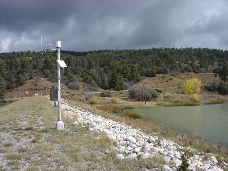
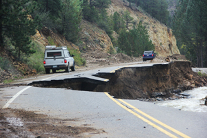
In October 2017, the Sonoma County region experienced several firestorms that left a blazing path of destruction and killed at least 25 people. In the aftermath, the communities faced a new danger as they struggled to recover. The resulting fire burn scars and ground conditions throughout the Tubbs and Nuns area had left the region highly vulnerable to life-threatening flash flooding and debris flows during heavy rainstorms. As they headed into California’s rainy season, Sonoma County and City of Santa Rosa officials knew that a flood warning network was needed as quickly as possible to assist the County and National Weather Service in detecting potential flooding conditions.
Led by Sonoma County Water Agency (SCWA) and working collaboratively with a team from OneRain and other local agencies, a plan was put in place to implement a new flood warning network for the region that would provide advanced warning for potential flash flood threats to the communities as they struggled to recover.
The timing and speed of installation of the new ALERT2-based radio telemetry network was critical. Strategic monitoring site locations within and downstream of the burn scar areas were chosen. OneRain conducted a radio path analysis and designed an optimized network plan that would leverage other existing ALERT2 networks in the area.
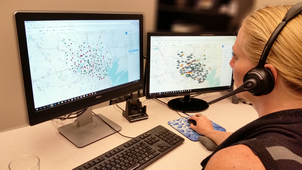
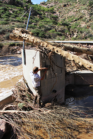
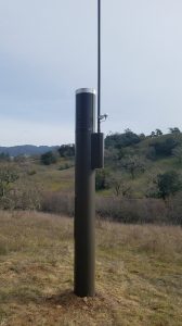
More than 25 HSE automated rainfall and streamflow gauges were installed by OneRain’s Field Services team. Soil moisture sensors were later installed to track saturation and potential slope destabilization in at-risk areas. OneRain’s Contrail® software platform provides SCWA with secure 24/7 real time data collection, archiving, monitoring, and visualization used in decision support. SCWA and other officials and responders receive advanced notifications of potential flood-threatening conditions via email and SMS. The data feeds sent from Contrail to the National Weather Service are used in developing their official active hazardous weather warnings and advisories. The general public can also view up-to-the-minute rainfall, streamflow, and other data at https://sonoma.onerain.com/.
The entire ALERT2™ Flood Warning network was fully operational in less than four months.
“The need on the heels of the October fires was imminent, and the pace at which we had to act was daunting.OneRain definitely stepped up to the plate to help us navigate this rapid deployment of our gauge network. Their expertise and professionalism were invaluable throughout the process,” said Jay Jasperse, Chief Engineer, Sonoma County Water Agency.
In a press release issued by the County of Sonoma and City of Santa Rosa, Brian Garcia, Warning Coordination Meteorologist with the National Weather Service said, “Knowing what is going on in real time is vitally important to the issuance of life-saving warnings, such as flash flood warnings. During rain storms we continually monitor the network of instrumentation across Sonoma County to maintain situational awareness.”
About OneRain Incorporated
Since 1992, OneRain has been providing solutions that optimize water management, heighten regulatory compliance, achieve successful civil works, and save lives. Headquartered in Longmont, Colorado, OneRain’s software and services deliver mission critical information to serve clients responsible for flood early warning, dam safety and reservoir operations, water resources, stormwater and wastewater management. For more information, visit www.onerain.com or call 800-758-RAIN (7246).
OneRain’s Support Team has been on hand assessing the real-time rainfall and hydrologic data and providing assistance to their clients and Emergency Coordinators in Storm Harvey’s path.
Our thoughts are with everyone impacted by storm Harvey. The entire OneRain team is focused on doing all we can to help and support our customers in Texas and Louisiana during this devastating event.
Officials from Harris County Flood Control District, San Jacinto River Authority, Trinity River Authority, Calcasieu Parish Police Jury, and other agencies in the storm’s path, are relying on the data transmitted from hundreds of gauges that are spread throughout the region. OneRain’s systems gather and provide the continuous real-time data measurements, analysis and reporting of the rainfall, stream flow and water levels in the dams from these gauges, providing critical notifications and information to their Emergency Coordinators and First Responders. The data from these systems are also used by the National Weather Service to assist in the official issuing of flood watches and other warnings to the public.
There are so many hard-working people behind the scenes who have had little or no rest as they keep these systems operating.
As rainfall subsides in the next few days, the ongoing challenge will be knowing where and how all this floodwater will drain and flow after this history-making rainfall and flooding storm event.
Please join us and other leaders, colleagues, and friends in the hydrologic warning community as OneRain and High Sierra Electronics both celebrate 25 years in business at a joint Technical Training and Open House event.
When: Friday, June 9, 2017 Time: 10:30 a.m. to 2:30 p.m. What: Four (4) *FREE* Technical Workshops, Facility Tour and Lunch Where: High Sierra Electronics, Inc., 155 Spring Hill Drive, Grass Valley, CA
Thank you to our clients, friends, and colleagues for your support during these past 25 years!
This event follows the National Hydrologic Warning Council 2017 Conference in Olympic Valley, California. HSE offices are just 60 minutes away from NHWC Conference at Squaw Creek
Make your plans now! We appreciate your response for our planning purposes.
About OneRain Incorporated
Since 1992, OneRain has been providing solutions that optimize water management, heighten regulatory compliance, achieve successful civil works, and save lives. Headquartered in Longmont, Colorado, OneRain’s software and services deliver mission critical information to serve clients responsible for flood early warning, dam safety and reservoir operations, water resources, stormwater and wastewater management. For more information, visit www.onerain.comor call 800-758-RAIN (7246).
About High Sierra Electronics, Incorporated
Established in 1992, High Sierra Electronics, Grass Valley, California, has been designing and manufacturing environmental monitoring systems for the protection of lives and property. High Sierra Electronics’ systems help identify threats posed by the weather, which include flooding, dangerous road conditions, and vulnerable dams and levees. For more information, visitwww.highsierraelectronics.com or call 800-275-2080.
Fire and Water: Hazards Management after Wildfires
Between shifting weather patterns and human activity, severe wildfires are becoming a more frequent occurrence. While the immediate effects of these fires are well known, it is the after effects, including flooding, that need to be closely managed.
Author: Anu Sood
One such example is the Las Conchas fire in New Mexico. On June 26, 2011, a tree fell on a power line in Santa Fe National Forest, which ignited the parched vegetation. The forest burned at an astounding rate of one acre per second, and by the time it was over, an estimated 156,000 acres of land had been burned. Among the areas burned were parts of Bandelier National Monument, Santa Clara Pueblo and Cochiti Pueblo. At the time, it was the largest recorded wildfire in New Mexico.
The loss of vegetation from the fire was just one of the catastrophic outcomes. With much of the vegetation removed and the ground becoming hydrophobic (or vitrified), intense downpour in the Jemez Mountains in August 2011 led to flash floods. Although newly implemented flood protection had reduced damage to the recently renovated historic visitor center, many park trails had been severely impacted.
“Ground conditions drastically change following wildfires—greatly increasing the potential for life-threatening flash flooding and mudslides during heavy rain.”
The Challenge
Knowing that it could take many years, and possibly decades, for the terrestrial ecosystem to recover, the agency responsible for maintaining the park set about to implement a more effective way to closely monitor the area’s water cycle. They were concerned about heavy rains and rising upstream water levels that could once again cause flash floods or landslides, thereby threatening lives and damaging property and park assets such as the visitor center. “To more closely guard the park against post-wildfire hazards, the local agency was looking for a system that would allow them to receive real-time notifications of rainfall and water level changes in various parts of the park,” said James Logan, CEO of OneRain.
Many of the systems in the market collected data regularly but are only able to send it at specific times or at specific intervals. This did not meet the crucial requirement to receive level information in real-time since water levels can rise very quickly right before a flood.
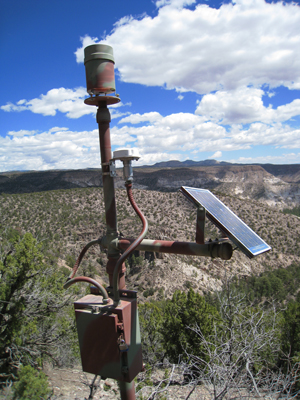
OneRain’s StormLink® Satellite Telemetry installed in the Cochiti fire burn area in northern New Mexico for flash flood warning. Real-time data is transmitted to OneRain’s secure data storage center for viewing, alarming and monitoring on the Internet via Contrail®
The Solution
OneRain developed and deployed several of their StormLink Monitoring Stations around the Santa Fe National Forest at Bandelier National Monument, Santa Clara Pueblo and the Cochiti Pueblo. Each consisted of either a rainfall gauge or a stream gauge connected to a satellite messaging terminal manufactured by SkyWave Mobile Communications and powered by a 10-watt solar panel.
OneRain’s StormLink solution provided many key functions and benefits for effective flood warnings. Since the system relied on satellite communications to relay data, monitoring stations were set up in mountains, canyons and other remote areas where other services are not available. Data from water gauges can be received by the monitoring software within 20 seconds of being collected and sent. This allows authorities to receive immediate notification when water levels rise rapidly during heavy rains and when data are needed in order to quickly assess risk levels.
OneRain’s Unique StormLink Protocol Guaranteed Timely Data Delivery for Advanced Warning To ensure that data were received by the flood monitoring software, OneRain implemented a unique StormLink® handshaking protocol between the satellite messaging terminal and theirContrail® monitoring software that guaranteed data delivery. If acknowledgement of data receipt was not received by the satellite messaging terminal, it would resend information.
Finally, OneRain devised the system so that water and weather data could be received, alarm thresholds defined and automated notifications for triggered alarm events delivered to any number of appropriate personnel to warn of possible flood conditions. Alarm notifications could be sent via both email and SMS text messages.
Intense Rainfall Event Puts the Advance Warning System to the Test
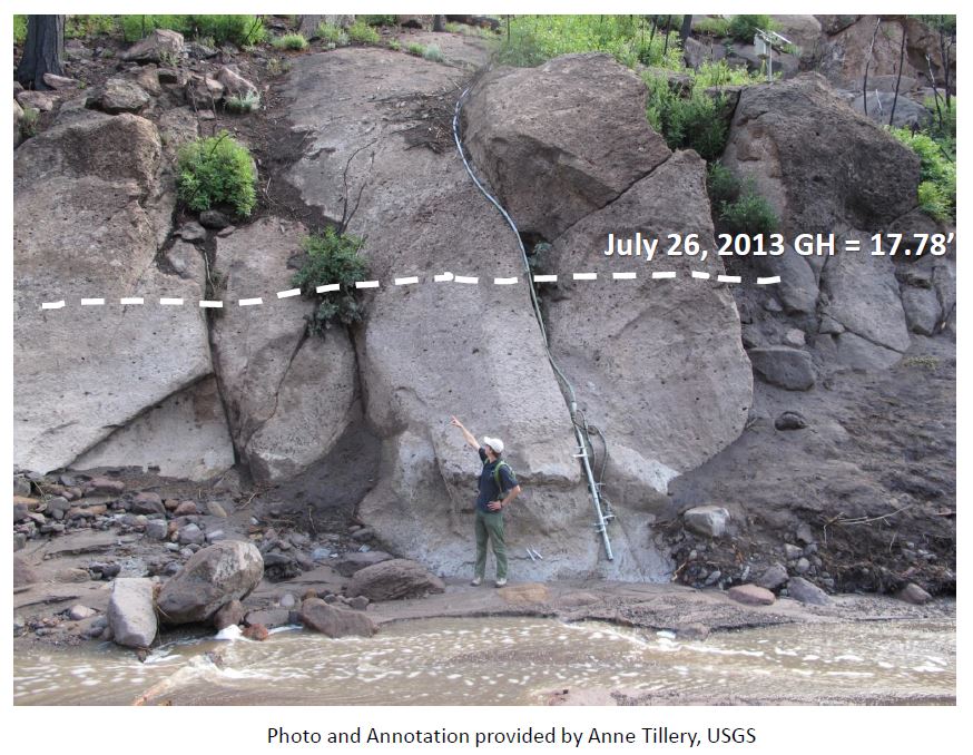
The remote monitoring solution’s capability was quickly tested for its effectiveness. On July 25, 2013, rains in the region led to a 17-foot (5.1-meter) high wall of water barreling through a local canyon towards the visitor center. “The real-time water level information allowed the local agencies to mobilize flood protection measures in advance,” said Logan “The early warning ensured that no one was hurt and damage to the visitor center and surrounding areas were minimized.”
About the Author Original story appeared in WaterWorld Magazine (www.waterworld.com). At the time published, Anu Sood was the Global Channel Marketing Manager at SkyWave Mobile Communications.
About OneRain Incorporated For more than 20 years, OneRain has been providing private and public sector clients across the United States and around the world with solutions to optimize water management, heighten regulatory compliance, achieve successful civil works, and save lives. OneRain’s innovative products and services serve clients in Flood Early Warning and Emergency Management, Dam Safety and Reservoir Operations, Water Resource Management, Post Wild Fire Mitigation, Urban Pluvial Water Management, and Stormwater and Wastewater Management. For more information, visit www.onerain.com or call 1-800-758-RAIN (7246).
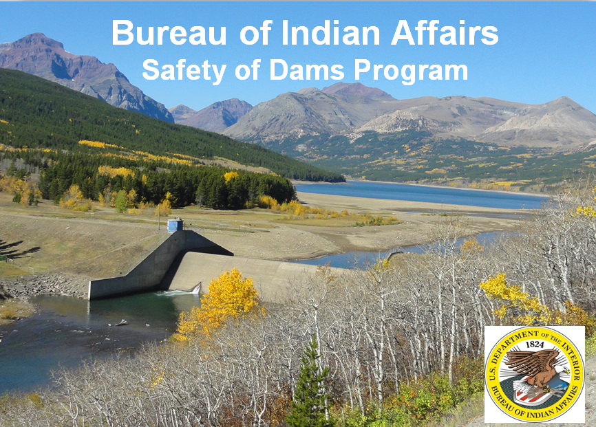
The Bureau of Indian Affairs (BIA) is responsible for 910 dams on Indian reservations; of which 137 are classified as high- and significant-hazard. Having been built several decades ago, many of the dams are not aging well and pose dam safety risks. BIA is actively modifying some of these dams to an acceptable safety level, however, with limited budgetary funds each year, a number of dams go unmodified until funding becomes available.
As part of the Bureau of Indian Affairs’ Safety of Dams program, BIA built and operates the National Monitoring Center, a 24/7/365-manned emergency operations center in Montana to ensure the safety of downstream communities. The dams are scattered on tribal lands throughout the western U.S.
Bureau of Indian Affairs Dam Safety Program uses OneRain’s Real-time Hazardous Flood Detection Solutions to support their National Monitoring Center.
The National Monitoring Center (NMC) Early Warning System is built upon the integrated real-time monitoring instrumentation, telemetry and centralized enterprise data collection services infrastructure developed by OneRain.
Under contract with the BIA since 2003, OneRain has been working in partnership with the agency’s Safety of Dams program supporting and continually enhancing the Early Warning System (EWS) in all aspects. OneRain and the NMC’s emergency personnel currently monitor more than 2,637 sensors for more than 112 high-hazard dams in real time. Key to the success of the program is knowing how well the instrumentation and sensors are performing at all times. The program includes daily system performance analysis that detects outages automatically. BIA, with OneRain, has an excellent preventive, proactive and routine inspection maintenance schedule in place for the monitoring instrumentation for ensuring that the flood warning network provides accurate, reliable information during a hydrological event.
Several sensors comprise OneRain’s remote dam safety monitoring instrumentation and gauges shown here at Lower Mundo Dam – part of the Bureau of Indian Affairs, Safety of Dams program.
The majority of the dam sites are on tribal lands in extremely remote locations. The Safety of Dams program uses OneRain’s StormLink™ real-time satellite systems to relay data from sensing sites and from local line-of-sight ALERT/ALERT2 or SCADA systems to OneRain’s data center where its decision-support software, Contrail®, continually collects and monitors rainfall, water level, stage height, flow rate data and more, in real time.
All the data coming in are automatically processed, analyzed and disseminated in real time in Contrail. Alarms events are triggered based on advanced customized rules and the system automatically generates and sends out early warning notifications with Emergency Action Plan (EAP) procedures to alert emergency personnel of possible hazardous and flood-threatening conditions. For example: if the stage height is near a bank full threshold, and it has rained more than 0.5-inches upstream in the last half hour, then an alarm is triggered. The alert notification system supports sending messages to cell phones, email, and text pagers. BIA and NMC staff have 24/7 secure web-based access to the system where they can see up-to-the-minute current conditions on high resolution maps, dashboards, charts, graphs and tables.
With OneRain’s system, the BIA and the NMC know at all times that their dam safety systems are up and running, or that it needs attention.
The National Monitoring Center is the key in providing significantly enhanced public safety to populations downstream from Bureau of Indian Affairs high-risk, significant-hazard dams.
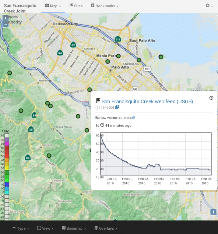
In the news February 2016: “Predicting El Niño’s flood risk: How new warning systems save lives, property”. OneRain’s Contrail® software provides the real-time monitoring and alerting for San Francisquito Creek Joint Powers Authority’s newly launched Flood Early Warning System. Check out this great article by journalist, Lisa Krieger with the Mercury News, focused on how automated remote data systems are helping protect communities in the San Francisco Bay area.
News Source: Lisa Krieger, San Jose Mercury News
Four winters ago, as worried rescuers watched the quickly rising waters of a Peninsula creek and tried to decide whether to alert local residents, they turned to a small green plant for guidance.
“You see that shrub?” one public safety official said. “When it’s under water, we’re going to start evacuating.”
Today, that sentinel shrub has been replaced by a sophisticated network of gauges, sensors and computers that can save lives and property — not only in flood-prone Menlo Park, Palo Alto and East Palo Alto, but also in vulnerable South Bay and East Bay communities.
OneRain’s Contrail® software provides the real-time monitoring and alerting for San Francisquito Creek Joint Powers Authority
Counting El Niño’s raindrops in distant mountains, the new flood-prediction systems are for the first time allowing the Bay Area to anticipate disasters, not merely respond to them.
“We can ramp up, adding resources and personnel,” said Menlo Park Fire Chief Harold Schapelhouman. “It becomes part of normal planning.”
A revolution in technology allows for the highly automated and near-instantaneous analysis of enormous volumes of digital information about water flow.
It works like this: Separate streams of data — collected from mountain peaks and rushing creeks — are integrated into huge databases. Computers then track rising waters and predict flood risk, based on creekbed capacity and the surrounding landscape.
As waters run high, the computers can issue an electronic flood alert to local residents downstream. For instance, mid-Peninsula residents who are registered to get an alert — by text or email — are kept informed about four different flood-prone locations along San Francisquito Creek. They will be notified nearly two hours in advance of the water overflowing its banks.
“We know what is coming down the system,” said Len Materman of San Francisquito Creek’s Joint Powers Authority, which has a newly expanded system of automated rain and creek gauges perched 2,000 feet above the vulnerable mid-Peninsula cities. “We can give people solid information for decision-making” about such things as when to sandbag, get electronics and antiques off the floor or seek higher ground.
To be sure, even the most high-tech upstream tools can’t predict flooding from surprise local sources, such as a suddenly downed tree or a blocked storm drain.
While we’ve long been able to accurately forecast flooding on major water routes like the Sacramento River, the risk along smaller urban tributaries — prone to flash floods, especially if lined with concrete — has been far tougher to predict.
Flooding is the leading cause of severe weather-related deaths in the U.S., causing 75 to 200 drownings per year. Because cars can be swept away in only 1 to 2 feet of water, about half of the drownings are vehicle-related.
In the last strong El Niño in the winter of 1997-1998, 1,700 homes were flooded on the Peninsula, and some residents had to be evacuated by boat. There also was damage in other Bay Area communities.
But history isn’t much help in predicting future risk because every storm is unique, with different rainfall patterns, experts say.
Steve Fitzgerald, president of the National Hydrologic Warning Council, has witnessed the recent and dramatic expansion of real-time, high-quality hydrologic information.
In 1983, as Hurricane Alicia bore down on his city of Houston, he was frustrated and fatigued by attempts to identify danger. Working 24 hours straight, he used a Wang computer to plot the data delivered by the county’s 12 rain gauges, imperfect devices rigged with weights and cables. Each graph took him 45 minutes to complete. Then, as rains pounded the city, the information quickly became obsolete and needed to be updated.
Now computer analyses of his county’s 150 electronic gauges and sensors take only seconds. “There has been quite a transformation,” said Fitzgerald, chief engineer of the Harris County Flood Control District.
Other cities with state-of-the-art flood prediction capabilities include Denver, Las Vegas, Los Angeles and Charlotte, North Carolina.
In the Bay Area, the newly expanded mid-Peninsula network was designed by hydrologists and data-crunchers at Berkeley-based Balance Hydrologics, using property volunteered by Stanford University, the Midpeninsula Regional Open Space District and San Mateo County Parks.
The Santa Clara Valley Water District has a network of 70 stream and rain gauges throughout the county, located along Los Gatos Creek, Stevens Creek, Alamitos Creek, Uvas Creek, the Guadalupe River and other sites.
Contra Costa County has three stream gauges, 29 rain gauges and one reservoir gauge, and it just received a grant to add 10 more stream gauges. It monitors Marsh Creek in the eastern part of the county and Walnut Creek in the central part of the county.
In Alameda County, a network of about 90 rain and stream gauges collects data used to estimate potential flood conditions. In the future, the county plans to expand its network to develop a database and Web tool that can be downloaded by residents.
The magic of the new technologies is that they can identify an emerging risk miles — and hours — away. Gauges, powered by solar panels, can accurately send electronic signals to data loggers via radio, landlines, cellphones or satellites. This data is more quickly analyzed due to increased computer power. And the flood risk is instantly communicated to nearby residents.
But, Materman said, it’s not enough to just gather information: “The first half of the problem is better data. The second half is: How do the public and emergency responders use that data?”
Increasingly, residents can go online to track water levels and changes in flow rates, said Gary Kremen, a board member of the Santa Clara Valley Water District. “There is greater transparency. It is empowering.”
But how well will this all work?
This winter’s El Niño could put it to the test.
“It is a work in progress,” Materman said. “Our work is based on models. We’ll need to ‘ground truth’ it.”
It’s far better, though, than keeping a watchful eye on a shrub, he said. “But it will take a real storm to see whether it behaves like we predict it should.”
BETTER GAUGING STATIONS: Rain gauges are 10-foot-tall pipes with a funnel, bucket and tipping mechanism at the top; each tip measures 0.04 inches of rainfall. Creek gauges have a membrane that precisely measures the depth of water and converts it into a flow rate, expressed in cubic feet per second.
IMPROVED DATA TRANSMISSION: Each time the rain gauge’s lever tips, its tiny internal computer sends a high-frequency radio transmission with the tip counter numbers to a receiver or repeater, then to a computer system. In creeks, the gauges convert the water’s depth to a flow rate, then transmit signals via phone lines.
FASTER ANALYSIS: With ever-increasing computer power, software processes the many signals into a computer database, which monitors the information as it is received. It triggers a warning when certain thresholds — say, water filling 80 percent of a creek’s capacity — are reached. Because different locations have different flood risks, the warnings can be localized.
ADVANCED COMPUTER MODELING: Instant access to project data is available through a cloud-based data center and can be viewed in real time or as a graph to identify trends. Using advanced math, topographic models can predict where and when water will likely go, if flooding occurs.
CELLPHONE ALERT SYSTEMS. In 2012, a California law went into effect that allows emergency alerts to be sent to cellphones, allowing flood control agencies to send automated warnings directly to the cell towers of major U.S. carriers, which then transmit those messages by text or email to phones. Residents of some communities can also track flood risk on websites.
###
Full Article Source: http://www.mercurynews.com/drought/ci_29453899/predicting-el-ninos-flood-risk-how-new-warning Contact Journalist Lisa M. Krieger at 650-492-4098. Follow her at Twitter.com/LisaMKrieger and Facebook.com/LisaMKrieger.
LONGMONT, COLORADO, August, 2015 – OneRain is pleased to announce its participation at Dam Safety 2015 where they will be showcasing their Active Dam Safety Monitoring solution. Dam Safety 2015 is the official national conference of the Association of State Dam Safety Officials (ASDSO), the premier educational and networking event in the dam safety industry that attracts attendees from all over the world. This year’s conference takes place September 13-17, 2015 in New Orleans, Louisiana. OneRain supports Dam Safety Monitoring programs where high-risk and significant-hazard designated dams pose a risk to extensive property damage or possible loss of human life due to mis-operation or dam failure.
Colorado-based OneRain (formerly DIAD Inc.) has been designing, building, rehabilitating, operating and maintaining real-time environmental monitoring systems to keep tabs on flood-prone waterways and dams since 1992. Their Active Dam Safety Monitoring solution can detect and alert threatening conditions in advance, automatically notifying dam owners and officials tasked with the safe operation and maintenance of the dam with crucial real-time information so they can make timely, well-informed operational decisions.
OneRain provides real-time monitoring and maintains gauge instrumentation at Spinney Mountain Reservoir, Aurora, Colorado. Photo credit: Scott Bores, Manager of Field Engineering, OneRain Inc.
Dam owners are responsible for maintaining a dam in a safe condition to reduce the risk a dam creates. Safe, cost-effective dam operations require reliable, timely environmental and dam status information.
“When it comes to Dam Safety monitoring programs, OneRain takes a complete systems approach to ensure dependable real-time remote monitoring,” says James Logan, OneRain’s CEO. Many of the dam monitoring sites are in very remote areas but with populations downstream that could be affected if anything goes wrong. For these early warning systems to be successful, highly available, reliable, accurate and timely data are paramount. Early detection of threatening conditions and severe storm events that could lead to failure, allows time for dam officials to issue early warnings, determine what areas might be affected and who may need to be evacuated. “To that end, OneRain’s complete solution approach gives us more effective control over the delivery, timeliness, quality and accuracy of the data that decision-makers rely on in making their assessments,” says Logan.
OneRain’s end-to-end Active Dam Safety Monitoring solution provides critical decision-support information in real time. The system provides Web and local visualization services, real-time satellite telemetry, and telemetry system integration as well as options for real-time gauge-adjusted radar-rainfall (GARR) data, basin-average rainfall and predictive/forecast rainfall estimates. GARR provides highly accurate rainfall estimates on a pixel and basin-accumulated basis and creates the most accurate estimates of reservoir inflow from rain currently available.
Data are gathered from an array of integrated real-time monitoring gauge instruments measuring reservoir elevation, flow, spillway, discharge, weather, rainfall, float switches, wind, temperature, vibrating wire piezometers, tiltmeters, inclinometers, seismic and more—these sensor data are collected, processed, analyzed and disseminated in real time by Contrail®, OneRain’s enterprise visualization and decision-support software. Dam operations personnel are able to access the system round-the-clock to know what’s going on at any particular point in time. Up-to-the-minute reporting is presented graphically in geo-referenced maps and visually informative dashboards that enable key personnel to quickly evaluate conditions at the dams. Designated officials and response personnel also receive automated advance warnings of potential problems via text message and email when predefined conditions and sensor thresholds are exceeded. Emergency Action Plan-related information is often included with these alert notifications to assist responding safety and emergency personnel.
Equally important is the quality of gauge instrumentation maintenance at the dam. Routine, preventative maintenance of the instrumentation at each dam location is key to ensuring that the early warning network provides accurate, reliable information during a hydrological event. OneRain’s Field Services group also provides these services and conducts best practices training on preventative, breakdown and reliablity-centered maintenance programs to ensure the highest network performance.
If you’re planning to be in New Orleans for the ASDSO Dam Safety 2015 Conference, be sure to stop by OneRain’s booth #300 to see a demo of their Active Dam Safety Monitoring solution.
About OneRain Incorporated
For more than 20 years, OneRain has been providing private and public sector clients across the United States and around the world with solutions to optimize water management, heighten regulatory compliance, achieve successful civil works, and save lives. OneRain’s innovative products and services serve clients in Flood Early Warning and Emergency Management, Dam Safety and Reservoir Operations, Water Resource Management, Post Wild Fire Mitigation, Urban Pluvial Water Management, and Stormwater and Wastewater Management. For more information, visit www.onerain.com or call 1-800-758-RAIN (7246).
About ASDSO
The failure of dams and the great destruction and loss of life failures often cause, is a matter of deep concern to the members of the Association of State Dam Safety Officials (ASDSO). ASDSO is a national non-profit organization serving state dam safety programs and the broader dam safety community, which includes federal dam safety professionals, dam owners and operators, engineering consultants, emergency managers, manufacturers, suppliers, academia, contractors, and others interested in improving dam safety.
LONGMONT, COLORADO, June 11, 2015 – OneRain’s Mike Zucosky will be taking a look at flood warning systems of the future in his presentation at the National Hydrologic Warning Council’s 2015 Training Conference & Exposition in Indianapolis, Indiana, June 15-18, 2015. OneRain Inc., a leading provider of real-time and historical hydrologic and rainfall-related data solutions, software and services, is a title sponsor and one of the main contributors of the biennial conference.
The growth and increasing robustness of Internet services, especially wireless access, has changed how and where flood early warning systems can be deployed. Cloud-based software services are also changing how data is collected and viewed during critical events. The development of Smart Cities and the rise of Social Media has also begun to open new paths for data collection and dissemination. At the same time, growing concerns over the privacy of data and security related to IT infrastructure will require proactive solutions to these potential problems.
OneRain’s presentation will examine these trends and present possible impacts that innovation in other fields may have on the design and implementation of flood warning systems years from now. It will explore the future of sensing, data transmission and collection, data sharing, collaboration and distribution. Today’s flood warning paradigms will shift. The future of flood warning systems will be a brave new world.
Photo credit: Fritz Law, OneRain, June 12, 2015. Urban Flooding East of Alameda and Santa Fe, Denver, Colorado
The 2015 National Hydrologic Warning Council (NHWC) biennial conference—the largest conference of its kind in the United States—will be attended by prominent federal and state officials and hydrologic warning professionals. As one of the main sponsors and industry experts, several other members of the OneRain team are presenting throughout the conference on a variety of topics including designing networks for ALERT2™, and the visualization tools that aid in those designs. Stop by OneRain’s booth where you can meet with the team and see some of the new features and enhancements recently added to OneRain’s Contrail® real-time hydrologic monitoring and warning software application.
For more information about the NHWC and the 2015 NHWC conference, “Advances in Hydrologic Warning – The Race to Save Lives.”, visit www.hydrologicwarning.org
About OneRain Incorporated
For more than 20 years, OneRain has been providing private and public sector clients across the United States and around the world with solutions to optimize water management, heighten regulatory compliance, achieve successful civil works, and save lives. OneRain’s innovative products and services serve clients in Flood Early Warning and Emergency Management, Dam Safety and Reservoir Operations, Water Resource Management, Post Wild Fire Mitigation, Urban Pluvial Water Management, and Stormwater and Wastewater Management. For more information, visit www.onerain.com or call 1-800-758-RAIN (7246).
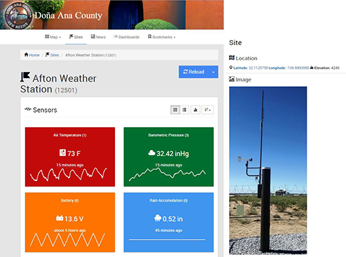
In the news November 2014: “New Rainfall Monitoring System to Aid in Flood Warning”. The Doña Ana County Flood Commission – in conjunction with the National Weather Service and other entities – has installed the first series of rainfall monitoring stations in Doña Ana County, data from which is available for viewing on the Internet.
The strategic placement of the monitoring sites is designed to predict flooding and enable a warning system for residents who may be in danger.
Doña Ana County Flood Commission Director Paul Dugie said the warning system represents an ongoing investment that augments diversion structures and dam maintenance with tool for residents to monitor rainfall in upstream areas.
“Residents of low-lying areas already know that it can be dry as a bone where they live, but if heavy rainfall is occurring in upstream areas, they can be at risk for flooding when the arroyos run,” Dugie said. “We view this system as one more important tool to protect lives and properties.”
Afton Weather Station – the very first ALERT2 site in Doña Ana County, Las Cruces, New Mexico.
The rainfall gauges all send data to a central tower on A Mountain east of Las Cruces, and a transmitter on that tower relays the information to the Doña Ana County Government Center, where it’s posted onto the Internet at https://weather.donaanacounty.org
Upon full implementation – which is estimated to be completed in 2017 – there will be 30 remote weather stations, stream gauges and water-level monitoring stations located throughout Doña Ana County, all of which will be linked to the National Weather Service and to other gauges in southern New Mexico and El Paso County.
“Not only will we be able to gather real time information with this system,” Dugie said, “but we’ll also be able to more closely track trends that will improve future forecast models.”
Dugie estimated that about $130,000 worth of equipment has already been integrated into the system, with an annual maintenance budget of about $30,000. In addition, he said his office has hired a flood warning system operator to oversee the system and its maintenance, both in the field and from the Doña Ana County Government Center.
In addition to Doña Ana County and the National Weather Service, other partners in the initiative include the Elephant Butte Irrigation District, the City of Las Cruces and New Mexico State University.
In addition to the rainfall gauges, a robotic camera has been acquired that can be used to monitor culverts for blockages and structural integrity, thereby improving the county’s ability to maintain and replace them before they fail. The robotic camera is attached to a specially equipped all-terrain vehicle that can access rugged areas in all kinds of weather. The recorded information and camera images can be saved to a central database.
News Source: https://donaanacounty.org/content/new-rainfall-monitoring-system-aid-flood-warnings
Read more about Doña Ana County’s flood warning system on the NM Climate Center’s blog: http://nmclimatecenter.blogspot.com/2014/11/new-rainfall-monitoring-system-for.html
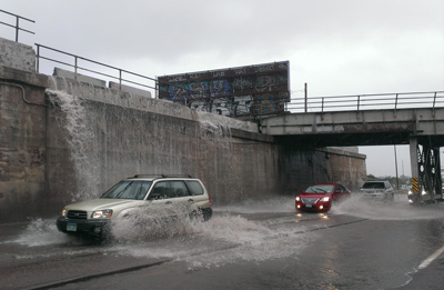
LONGMONT, COLORADO, October 1, 2013 – It’s been a busy time here in Colorado as our team has been supporting the recovery efforts from last month’s epic flood event.
OneRain field truck follows a detective through flood devastated area
OneRain installed and currently maintains a considerable number of the hydrologic gauges along the Colorado Front Range and provides the software for real-time data collection, monitoring and alerting. Members of our field staff have been seeing first hand, the destruction and devastation that the powerful floodwaters caused, as they venture out to perform maintenance and evaluate the condition of gauges in the network.
OneRain field staff attempt to access gauge to evaluate a flood-damaged gauge site
Our systems performed well during this historic event. Our software application, Contrail®, provided the continuous real-time data collection, early warning alarming, and notifications and monitoring of the numerous rainfall, stage, and stream flow gauge sites in the region, while several of our personnel were on hand in the midst of the storm assessing the data and providing assistance to coordinators and first responders in the Emergency Operations Center.
The OneRain team is passionate and committed to helping our local agencies in their missions to detect, reduce risks, respond, and minimize losses in potential flood-producing rainfall storm events and our thoughts are with all those impacted by this devastating flood that hit our home state.
 OneRain’s Contrail® software platform provides SCWA with secure 24/7 real time data collection, archiving, monitoring, and visualization used in decision support. SCWA and other officials and responders receive advanced notifications of potential flood-threatening conditions via email and SMS. The data feeds sent from Contrail to the National Weather Service are used in developing their official active hazardous weather warnings and advisories. The general public can also view up-to-the-minute rainfall, streamflow, and other data at https://sonoma.onerain.com/.